by: admin
-
ديسمبر 8, 2025
-
Comments (0)
Real estate map with nearby landmarks for confident buyers
Real estate map with nearby landmarks helps buyers understand location context instantly and make confident decisions.
mtc combines this map with Virtual tour experiences that showcase your real estate project clearly.
Clients see the property, the neighborhood, and surrounding services in one consistent digital experience.
This clear overview reduces confusion, builds trust, and prepares serious buyers before any sales conversation.
You answer location questions visually, instead of relying on long descriptions or static brochures.
Real estate map with nearby landmarks for project site exploration
A real estate map with nearby landmarks lets users explore the project location visually, not abstractly.
They can move around streets, check entrances, and understand how the project sits within its neighborhood.
This visual context helps international and local buyers feel oriented before visiting the site in person.
mtc integrates the real estate map with nearby landmarks directly inside your Virtual tour experience.
Viewers can switch smoothly between street overview and immersive interior views without feeling lost or overwhelmed.
This alignment between map and tour keeps attention high and encourages deeper interaction with your project.
This seamless experience reflects modern customer expectations and positions mtc as a forward thinking real estate partner.
Interactive property location map highlighting key nearby amenities
Using an interactive property location map, you highlight schools, hospitals, malls, and main access roads.
Buyers instantly see how daily needs, healthcare, and entertainment connect directly to the project location.
This saves your team time explaining basics and supports clear comparisons between separate projects or phases.
mtc customizes each icon and label so every nearby landmark appears professional, consistent, and fully on brand.
The interactive map becomes a compelling story about lifestyle, convenience, connectivity, and everyday living potential.
Families understand schools and services, while investors evaluate long term demand and rental attractiveness quickly.
Explore our sample project virtual tour to see how this mapping experience works in action.
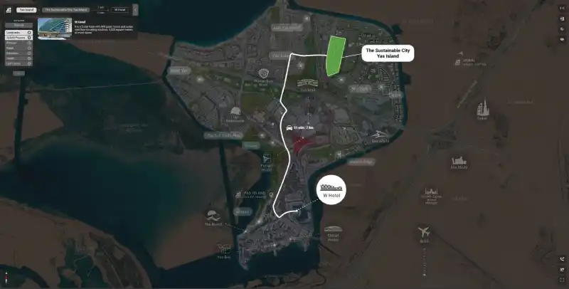
Real estate map with nearby landmarks showing distance and travel time
An intelligent property location map can display precise distances in kilometers to every important destination.
Buyers also see estimated travel times in minutes, based on realistic routes and typical traffic expectations.
This level of transparency prevents disappointment and reduces complaints about access, congestion, or hidden location drawbacks.
mtc uses accurate map data so your Virtual tour communicates reliable information that matches on site reality.
Together, map and tour position your project as trustworthy, innovative, and ready for serious investment decisions.
Serious buyers feel informed, respected, and ready to move from online exploration toward real commitments.